
If you spend enough time around Lake Naivasha, you eventually stop noticing Mount Longonot.
It is simply there.
From the lake, from the roads, from the surrounding farms and lodges, the enormous volcanic cone sits on the horizon. Sometimes it is sharply defined against a clear blue sky. Sometimes clouds gather around its summit. At other times, it almost disappears into the haze of the Rift Valley.
For many visitors to Naivasha, Longonot is simply the mountain they see in the distance.
But Longonot is much more than a mountain.
It is the remains of a volcano that has repeatedly reshaped the landscape around it. It is part of the geological story of the Great Rift Valley, a refuge for wildlife, a protected area and a place where geology and ecology meet in a particularly spectacular way.
And, perhaps most remarkably, the mountain we see today is only part of the volcano's story.
A volcano in the Rift
Mount Longonot lies in Kenya's Great Rift Valley, southeast of Lake Naivasha.
The Rift Valley is not simply a valley in the ordinary sense. It is part of a huge geological system where the African continent is slowly being pulled apart.
Deep beneath the surface, the Earth's crust is being stretched. As it thins and fractures, molten rock from deeper within the Earth can find pathways towards the surface.
This is one of the reasons why the Rift Valley is dotted with volcanoes.
Longonot is one of them.
At 2,776 metres above sea level, it rises dramatically above the surrounding landscape. Its name comes from the Maasai word Oloonong'ot, generally translated as something along the lines of "mountain of many spurs" or "mountain of steep ridges".
A fitting description when you look closely at its deeply cut slopes.
But the mountain's current shape hides a much larger story.
The volcano beneath the volcano
From a distance, Longonot looks like a fairly classic volcanic cone.
It isn't quite that simple.
The present-day central cone was built inside a much older and much larger volcanic depression. A caldera measuring approximately 8 by 12 kilometres.
That means that the Longonot we see today was, in geological terms, built inside the remains of an older volcanic structure.
Around 21,000 years ago, enormous explosive eruptions helped form this large caldera. Later eruptions built the central cone within it. Lava subsequently flowed across parts of the caldera floor and down the flanks of the volcano.
And sitting on top of that central cone is yet another depression: the roughly 1.8-kilometre-wide summit crater.
So when you stand on the rim of Longonot, you are effectively standing on the edge of a crater inside a much larger volcanic landscape that itself sits within the remains of an even older eruption.
The mountain is almost like a geological Russian doll.
What happens when a volcano erupts?
Volcanoes are often imagined as mountains with a hole at the top, waiting for lava to spill out.
The reality is considerably more complicated.
An eruption happens when magma — molten rock beneath the Earth's surface — finds a pathway upwards. As it rises, pressure decreases and dissolved gases can come out of solution. Depending on the composition of the magma, the amount of gas and the structure of the volcano, an eruption can range from relatively gentle lava flows to highly explosive events involving ash and fragmented rock.
Longonot's history includes both explosive and lava-producing activity.
Its older eruptions left ash and other volcanic deposits across the landscape, while later activity produced lava flows on the caldera floor and the outer slopes.
The landscape around the volcano is therefore, quite literally, made partly from the remains of its own eruptions.
Over thousands of years, weathering then takes over.
Rock breaks down.
Plants colonise the surface.
Soils develop.
Water begins carving valleys.
Animals move in.
Something that began as molten rock eventually becomes a living ecosystem.
Longonot has erupted in recent history
When we talk about volcanic activity around Longonot, we are not talking only about events from some impossibly distant geological past.
The Smithsonian's Global Volcanism Program records confirmed eruptive periods around 7,200 BCE, 1,330 BCE and, much more recently, around 1863! The 19th-century activity is associated with the northern flank, although the precise nature of that eruption is less certain than the older dated events. Maasai tradition also records a lava flow on the northern side of the mountain during this period.
In geological terms, 1863 was almost yesterday.
There are no known recent eruptions since then, and there are no current volcanic activity reports for Longonot from the Smithsonian's Global Volcanism Program. But the word "dormant" is perhaps more useful here than "dead".
Longonot is a volcano that has been quiet for a long time.
That is not the same thing as saying that it can never erupt again.
The crater
The summit crater is one of the most fascinating parts of Longonot.
From the rim, it can initially look like a giant empty bowl.
It isn't.
The crater floor contains a dense forest, creating a striking contrast with the open, dry-looking slopes outside. The steep walls and enclosed nature of the crater create a somewhat sheltered environment, and vegetation has been able to establish itself within it. Kenya Wildlife Service (KWS) describes the crater as having a dense, secluded forest.
There are also smaller volcanic features inside the larger crater, including evidence of later lava activity.
The result is an unusual landscape: a forest growing inside the summit of a volcano, surrounded by steep volcanic walls and sitting hundreds of metres above the Rift Valley floor.
From the rim, it is easy to forget that you are looking into the remains of an active geological system.It looks almost peaceful.
A mountain full of wildlife
Longonot is not usually the first place that comes to mind when people think of Kenya's wildlife.
There are no vast plains filled with thousands of Wildebeest here.
There are no famous predator sightings comparable to the Maasai Mara.
And yet, Longonot has its own wildlife story.
Buffalo, Zebra, Giraffe, Eland, Grant's gazelle, Bushbuck and Warthog are among the species associated with the park.
Some animals are easier to find than others.
Zebra and other grazers can often be encountered around the lower slopes and surrounding grasslands. Buffalo may use the more sheltered vegetation, while Leopard (I am pretty sure they pass through the area from time to time) are considerably more elusive and are basically never encountered.
And then there are the animals that remind you how much wildlife exists here without ever being seen.
Spotted Hyena may pass through the wider landscape, leaving tracks or calling at night.
Small carnivores such as Caracal are much more secretive and are not animals you should expect to encounter on every visit. Their presence is better understood as part of the wider ecosystem than as a guaranteed sighting.
That is one of the pleasures of a place like Longonot.
You may see the animal.
Or you may only see its tracks.
Sometimes the tracks tell you just as much.
Look up
For me, however, one of Longonot's greatest wildlife attractions is above your head.
The mountain is particularly well suited to watching birds of prey.
Warm air rising along the steep volcanic slopes creates thermals, and these invisible columns of rising air can be used by large birds to gain height without constantly flapping their wings.
Eagles, Buzzards and other raptors can often be seen circling above the crater and ridges.
KWS describes Longonot as a particularly good area for birds of prey, and species recorded in the wider area include impressive raptors such as Verreaux's eagle and Augur buzzard.
For a birder, there is another interesting aspect to the mountain.
The combination of altitude, open grassland, rocky slopes, forest and the surrounding Naivasha ecosystem creates a variety of habitats within a relatively small area.
The crater forest, in particular, can feel surprisingly different from the dry slopes outside.
And this is another reminder that geology eventually becomes biology.
The volcano determines the shape of the land.
The shape of the land influences vegetation.
Vegetation creates habitat.
And habitat determines which animals can live there.
A mountain protected by a national park
Mount Longonot National Park was gazetted in 1983 and covers approximately 52 square kilometres. Its purpose is not simply to protect a scenic mountain, but to conserve its volcanic landscape and associated ecological features.
Today, the park is primarily known for hiking and the spectacular walk around the crater rim.
There are no roads circling the crater.
To really experience Longonot, you have to walk.
And that changes the experience completely.
From the rim, Lake Naivasha appears far below. The Rift Valley stretches into the distance. The crater opens up on one side, while the surrounding landscape extends towards other volcanic mountains and escarpments.
You begin to understand why Longonot is such an important landmark.
It isn't simply sitting in the Rift Valley.
It helps define the way the Rift Valley looks.
Conservation beyond the park boundary
But protecting the mountain itself is only part of the conservation story.
Wildlife does not recognise National Park boundaries.
A Zebra does not know where the park ends.
A Leopard certainly doesn't.
Animals move between protected areas, ranches, agricultural land and other parts of the wider landscape.
This is particularly important around Naivasha, where wildlife conservation exists alongside farming, livestock, settlements, tourism and major economic activity.
The wider Longonot–Hell's Gate landscape therefore becomes a question of coexistence.
How do we protect wildlife while people continue to live and work around it?
How much land needs to remain connected?
What happens when wildlife moves outside a protected area?
And how do we conserve a volcanic ecosystem while also making use of the resources that exist beneath and around it?
These are not questions with simple answers.
Conservation rarely happens in an empty landscape.
A landscape still changing
Perhaps the most fascinating thing about Longonot is that it is easy to think of it as finished.
The eruptions stopped.
The lava cooled.
The crater filled with vegetation.
A National Park was created.
People now hike around the rim and photograph the views.
But geologically speaking, Longonot is not a finished object.
The Rift Valley is still changing.
The African continent is still being pulled apart.
Volcanic systems across the Kenyan Rift remain part of that geological process, and geothermal activity around the Naivasha area is a visible reminder that the Earth's heat is still very much present beneath the surface.
Longonot simply happens to be quiet at the moment.
And meanwhile, erosion continues.
Rain cuts into the volcanic slopes.
Plants break down rock.
Animals graze the vegetation.
Birds nest in the cliffs.
Forests grow inside the crater.
The landscape continues to change — just at a pace that is much easier for us to live with.
The mountain behind Naivasha
Every time you look across Lake Naivasha and see Longonot, you are looking at much more than a mountain.
You are looking at the remains of enormous eruptions.
At a volcano built inside an older volcanic caldera.
At lava that once flowed across a landscape that looked completely different from the one we see today.
At a crater that has become a forest.
At a mountain shaped by the forces that are slowly pulling Africa apart.
And at a protected landscape where Buffalo, Zebra, Giraffe, Antelopes, predators and birds share the slopes and forests created by those ancient geological events.
Perhaps that is what makes Longonot so easy to overlook.
It is always there.
Quietly sitting behind Naivasha while life continues around it.
But the next time you see that familiar silhouette rising above the lake, it might be worth looking a little longer.
Because beneath the grass, the forest and the wildlife is a story that began long before any of us were here.
And, in geological terms, it is not over yet.
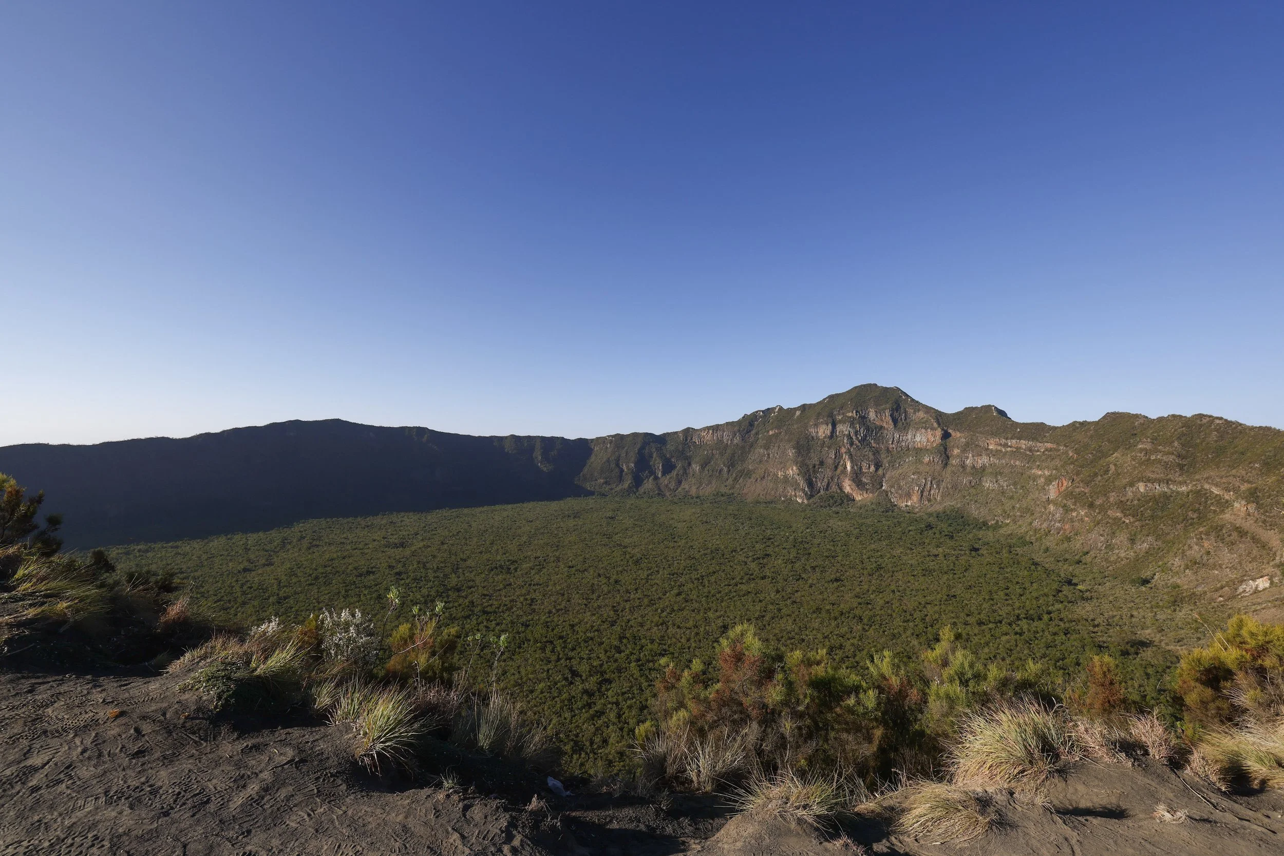
View from the crater rim
